**Overnight Lightning Strikes: A Weekend of Turbulent Weather**
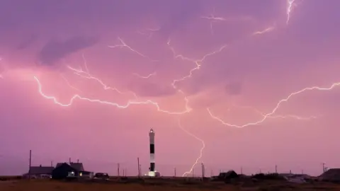
In an extraordinary weather event, more than 30,000 lightning strikes were recorded overnight up to 06:00 on Saturday, June 14, 2025, as thunderstorms rapidly swept across several regions of England, according to data provided by the Met Office. This staggering number of strikes highlights an intense atmospheric reaction following a surge in temperature that marked the hottest day of the year thus far, with areas in West Suffolk experiencing sweltering highs of 29.4°C.
Despite the ominous nature of the lightning, the majority of these strikes occurred over the sea rather than on land. However, significant rain fell in various regions, particularly in Kent, where heavy downpours caused flooding in areas like Dover, leading to disruptions for local residents. Yellow weather warnings for rain and thunderstorms were, therefore, issued for extensive regions, including Wales, western and northern England, Scotland, and parts of Northern Ireland, extending through Saturday to mitigate any potential hazards arising from the volatile weather conditions.
The thunderstorms rolled into the affected areas around 22:00 BST on Friday following a day characterized by scorching temperatures, which exceeded the prior seasonal high of 29.3°C recorded in Kew, London, on May 1. Scotland also enjoyed a particularly warm day, with Lossiemouth in Moray recording temperatures soaring to 25.7°C. A spokesperson from the Met Office remarked that temperatures in southeast England were notably elevated, ranging comfortably between 9°C to 10°C higher than the average anticipated for this time of year.
In advance of the storm’s arrival, an amber warning for thunderstorms was enacted from Eastbourne in the south to Cromer in north Norfolk, alerting residents of the impending severe weather from 20:00 BST Friday until the early hours of Saturday. As conditions progressed, the Met Office issued updated weather alerts that remained in effect through Saturday afternoon.
Despite the unfriendly weather, it wasn’t just the southeast that faced the brunt of the rainfall. In Devon, the rainfall reached a staggering 36.4mm near Okehampton, leading to the Environment Agency issuing five flood warnings in the South West area, alongside 49 flood alerts throughout regions in the South West, South East, and the Midlands. Additionally, authorities in South Wales issued another six flood alerts due to the deteriorating weather conditions.
Late Friday evening, Heathrow Airport released apologies to travelers affected by flight delays attributed to “adverse weather conditions.” In St Leonards-on-Sea, a lightning strike was suspected to have caused a fire in a residential building, although no casualties were reported, and the fire was swiftly extinguished.
As the storm clouds gathered, the Met Office warned that some areas could anticipate between 30-50mm of rain within just a few hours, while isolated locations might witness precipitation levels soaring up to 80mm. A further yellow warning was also implemented throughout the eastern portion of Northern Ireland for Saturday, indicating that severe weather was far from over.
While some regions braced for continuing rain showers, there was also the prospect of a shift as the heat and humidity were expected to gradually settle, marking an end to the uncomfortably high temperatures that had prevails in northern and eastern parts of England. As conditions evolve, forecasts predict lower highs in the low to mid-twenties across eastern England, paired with high teens in other areas.
The aftermath of this tumultuous weather will linger through the weekend, as more communities and local authorities remain alert and prepared for any further unpredictable weather patterns from this unprecedented storm.


